Decision time for the Scarborough shore: What kind of waterfront do we deserve?
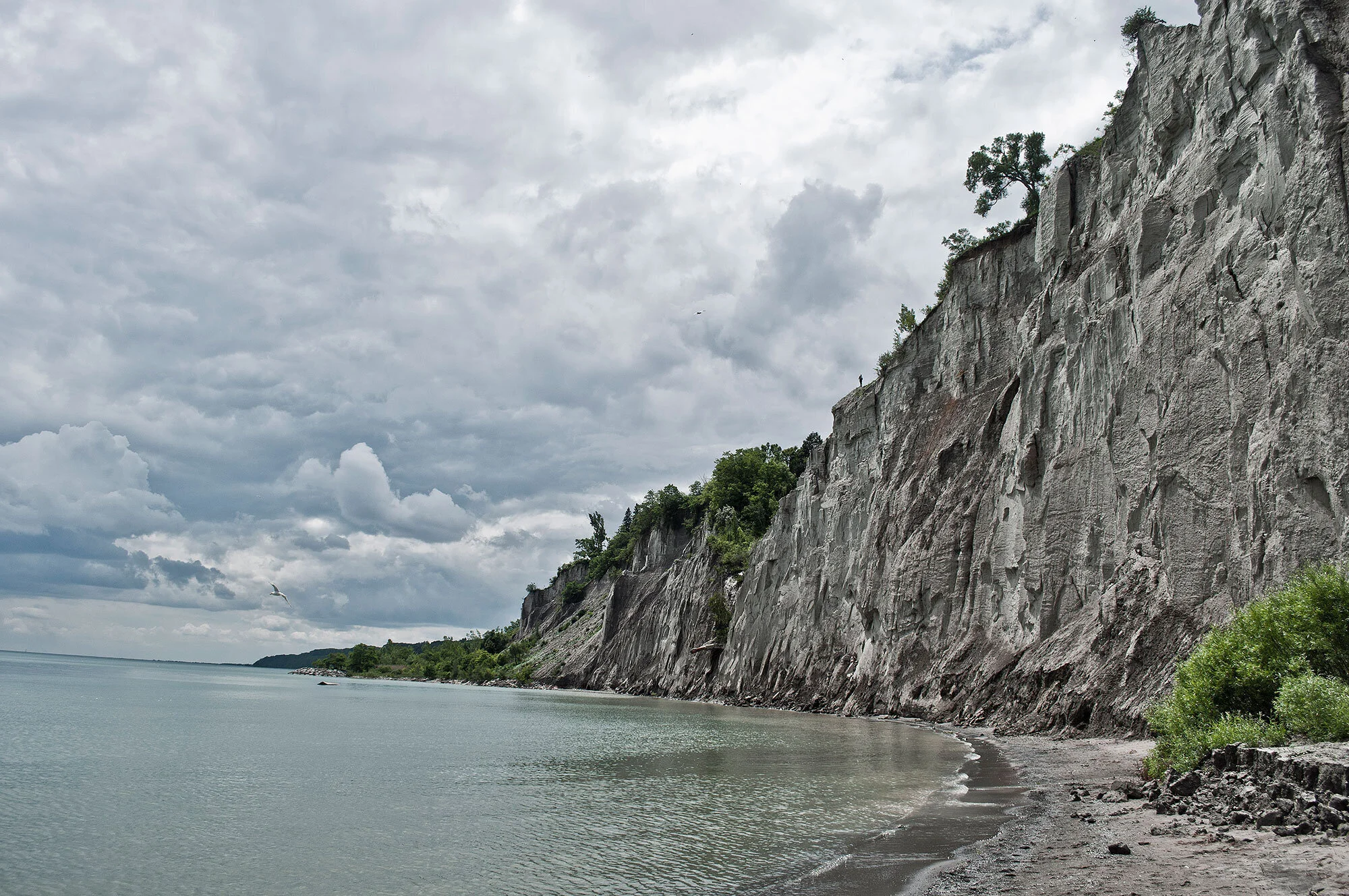
Scarborough Bluffs at Bluffers Park. (Photo by Philip Li)
Author of "Along the Shore: Rediscovering Toronto’s Waterfront," Jane Fairburn wants to draw attention to a major facelift coming to the Scarborough waterfront. She submitted this guest post highlighting the Toronto Region Conservation Authority's proposal and citing some of her personal concerns. Waterkeeper is now reviewing the proposal and will draft our own comment soon.
If you have something to say, the first deadline for public comment is February 11, 2016.
Recently, the primary focus of Toronto’s waterfront development has been on the transformation taking place in the downtown harbour and its oft perceived errant cousin to the west, Humber Bay. Few recognize that another transformation of no less magnitude is about to begin on the eastern shore in the Scarborough Bluffs, where the land rises 250 feet over the water’s edge. The Toronto and Region Conservation Authority (TRCA) is currently planning a major overhaul of about 11 kilometres of the Scarborough waterfront, from Bluffer’s Park in the west to East Point Park, near the mouth of Highland Creek. Make no mistake about it — this is a very big decision that has the potential to fundamentally alter the contour and shape of the eastern waterfront, and the way we relate to the lake, for generations to come. For example, north/south access points to the lake at Bluffer’s Park, the Doris McCarthy Trail (historic Gates Gully), Guild Park and Gardens and East Point will eventually be developed so that many more people, city wide, will be able to get down to the water. Let me say at the outset that I’m all for increasing access to the lake – it is our greatest public asset. That said, waterfront development is always a balancing act. As I said in Along the Shore, “The irony is that bringing people down to the water also brings destruction. In conservation there is loss, and in development there is always change.” I don’t think any of us really understands the enormity of the change that is potentially coming.
Download the TRCA's Alternatives for shoreline development (starting on page 19)
One of my main concerns is that what little beach and Bluffs area we still have left stands to be “gobbled up” in the desire to allow cyclists (and others) the ability to move along the entire length of the waterfront, unimpeded. Specifically, check out the TRCA’s disastrous “Headland-Beach” alternative at the east end of Bluffer’s Park (alternatives begin on page 18 — scroll down from there as the shoreline is divided into three segments and the alternatives move from east to west). If this alternative is ultimately adopted, at least one third of Bluffer’s beach (many would say our best beach, city-wide) would be re-worked into a hardened armour rock and cobble structure at the water’s edge. The reason for such disruptive change? Apparently to facilitate a linkage to a newly minted section of the Waterfront Trail, which begins under Meadowcliffe Drive, a relatively short distance to the east. In this scenario, the natural Bluff face, situated in between the beach and the Meadowcliffe trail at Cudia Park, would be starved of the erosion process that in some sections exposes almost the complete history of 75,000 years of our geological past.
In fairness, the TRCA has offered less intrusive alternatives for linking Bluffer’s beach to the Waterfront Trail at Meadowcliffe, including an expanded beach with boardwalk (contained in the document above). It continues to do wonderful work, preserving our ecological and natural heritage, city wide. I’ll be reviewing all the alternatives over the next few days. I urge you to do the same and to send in your comments, either by email or letter, to Lindsay Clapp, Project Manager, waterfront@trca.on.ca (101 Exchange Avenue, Vaughan, ON, L4K 5R6). You may also respond in the comments section of the TRCA's workbook document noted here. My view is that our natural and cultural heritage should not be unduly compromised for the sake of increased access to Lake Ontario – any option that destroys the remaining Bluff faces over time, severely limits unobstructed views of the water and/or compromises the remarkably varied wildlife that inhabits the shore is simply unacceptable.
Incidentally, has anyone ever been to East Point Park, farther to the east? East Point is, geologically speaking, the eastern termination point of the Scarborough Bluffs. It is also our last remaining natural beach in the city, and it is a beauty. Can anyone honestly say with a straight face that destroying the natural beach and lining the shore with armour rock actually deepens our connection to the lake and the natural world? Ask yourselves folks: Would a similar action ever be contemplated at Toronto Island, where many of the natural beaches are constantly eroding? (See Gibraltar Point Erosion Control Project.) The Waterfront Trail and a series of other connected trails already exist near the edge of the Bluffs. The solution to accessibility in this area is clear – leave the cyclists to their own devices at the top of the embankment. They’ll survive just fine. I’m asking you to send in your thoughts on Scarborough shoreline development to the TRCA asap, as the deadline is February 11, 2016.
Please also remember: Toronto’s waterfront is for everyone, regardless of where we happen to live in the city. To friends in the west, south and north of our great city: please feel more than free to send in your comments to the TRCA.
As always,
Jane
janefairburn.com